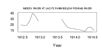
| PointID: | 2815 | Code: | 05LJ001 | Latitude (decimal degrees): | 51.46 | Longitude (decimal degrees): | -99.98 | Drainage Area (km2): | 8990.00 | Source: | Hydat | Hydrological Zone: | Nelson | Name: | MOSSY RIVER AT LACY'S FARM BELOW FISHING RIVER |
|---|
| Download | |
|---|---|
| Site Descriptor Information | Site Time Series Data |
| Link to all available data | |
| ID | Year | Jan | Feb | Mar | Apr | May | Jun | Jul | Aug | Sep | Oct | Nov | Dec |
|---|---|---|---|---|---|---|---|---|---|---|---|---|---|
| 2815 | 1912 | 24.40 | 23.20 | 23.10 | 30.80 | 45.00 | 40.00 | 31.00 | |||||
| 2815 | 1913 | 34.80 | 26.10 | 20.10 | 18.00 | 18.00 | |||||||
| 2815 | 1914 | 16.00 | 16.00 | 14.00 | 13.00 | 19.70 | 20.20 | 14.80 |
 Return to R-Arctic Net Home Page