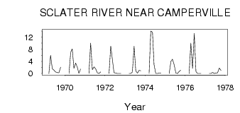
| PointID: | 2810 | Code: | 05LG005 | Latitude (decimal degrees): | 51.99 | Longitude (decimal degrees): | -100.23 | Drainage Area (km2): | 393.00 | Source: | Hydat | Hydrological Zone: | Nelson | Name: | SCLATER RIVER NEAR CAMPERVILLE |
|---|
| Download | |
|---|---|
| Site Descriptor Information | Site Time Series Data |
| Link to all available data | |
| ID | Year | Jan | Feb | Mar | Apr | May | Jun | Jul | Aug | Sep | Oct | Nov | Dec |
|---|---|---|---|---|---|---|---|---|---|---|---|---|---|
| 2810 | 1969 | 0.00 | 6.00 | 1.58 | 1.13 | 0.50 | 0.29 | 0.26 | 2.07 | ||||
| 2810 | 1970 | 0.00 | 7.00 | 8.12 | 1.69 | 3.41 | 2.02 | 0.07 | 1.48 | ||||
| 2810 | 1971 | 0.00 | 10.00 | 1.25 | 2.17 | 1.48 | 0.26 | 8.0e-03 | 0.54 | ||||
| 2810 | 1972 | 0.00 | 9.00 | 4.44 | 0.28 | 0.13 | 0.03 | 1.0e-03 | 2.0e-03 | ||||
| 2810 | 1973 | 0.00 | 0.00 | 0.44 | 8.96 | 0.81 | 0.12 | 1.05 | 0.92 | ||||
| 2810 | 1974 | 0.00 | 14.00 | 13.60 | 2.96 | 0.03 | 4.0e-03 | 0.15 | 0.19 | ||||
| 2810 | 1975 | 0.00 | 4.00 | 4.72 | 2.91 | 0.12 | 1.0e-03 | 0.65 | 1.15 | ||||
| 2810 | 1976 | 0.00 | 10.00 | 1.70 | 13.20 | 0.64 | 0.02 | 1.0e-03 | 0.00 | ||||
| 2810 | 1977 | 0.00 | 0.00 | 0.36 | 0.02 | 0.13 | 0.23 | 1.81 | 1.01 |
 Return to R-Arctic Net Home Page