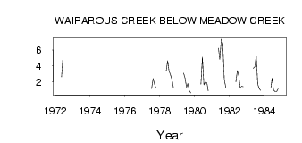
| PointID: | 279 | Code: | 05BG009 | Latitude (decimal degrees): | 51.36 | Longitude (decimal degrees): | -114.99 | Drainage Area (km2): | 230.00 | Source: | Hydat | Hydrological Zone: | Nelson | Name: | WAIPAROUS CREEK BELOW MEADOW CREEK |
|---|
| Download | |
|---|---|
| Site Descriptor Information | Site Time Series Data |
| Link to all available data | |
| ID | Year | Jan | Feb | Mar | Apr | May | Jun | Jul | Aug | Sep | Oct | Nov | Dec |
|---|---|---|---|---|---|---|---|---|---|---|---|---|---|
| 279 | 1972 | 2.62 | 5.26 | ||||||||||
| 279 | 1977 | 1.14 | 2.39 | 1.67 | 1.25 | ||||||||
| 279 | 1978 | 3.34 | 4.64 | 3.39 | 2.85 | 2.28 | 1.22 | ||||||
| 279 | 1979 | 3.11 | 2.45 | 1.30 | 1.79 | 0.87 | 0.58 | ||||||
| 279 | 1980 | 1.69 | 5.09 | 1.61 | 1.94 | 1.85 | 0.87 | ||||||
| 279 | 1981 | 6.21 | 4.80 | 7.35 | 6.80 | 2.28 | 1.26 | ||||||
| 279 | 1982 | 1.97 | 3.40 | 2.71 | 1.23 | 1.43 | 1.37 | ||||||
| 279 | 1983 | 3.69 | 3.86 | 5.28 | 1.69 | 1.18 | 0.90 | ||||||
| 279 | 1984 | 1.19 | 2.45 | 0.93 | 0.75 | 0.76 | 1.10 |
 Return to R-Arctic Net Home Page