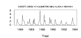
| PointID: | 2781 | Code: | 10CD005 | Latitude (decimal degrees): | 58.10 | Longitude (decimal degrees): | -122.71 | Drainage Area (km2): | 109.00 | Source: | Hydat | Hydrological Zone: | Mackenzie | Name: | ADSETT CREEK AT KILOMETRE 386.0 ALASKA HIGHWAY |
|---|
| Download | |
|---|---|
| Site Descriptor Information | Site Time Series Data |
| Link to all available data | |
| ID | Year | Jan | Feb | Mar | Apr | May | Jun | Jul | Aug | Sep | Oct | Nov | Dec |
|---|---|---|---|---|---|---|---|---|---|---|---|---|---|
| 2781 | 1983 | 0.00 | 2.18 | 3.11 | 1.12 | 0.86 | 0.53 | 0.30 | 0.00 | 0.00 | |||
| 2781 | 1984 | 0.00 | 0.00 | 0.00 | 0.00 | 5.52 | 3.07 | 2.17 | 2.14 | 2.15 | 0.34 | 0.00 | 0.00 |
| 2781 | 1985 | 0.00 | 0.00 | 0.00 | 0.00 | 1.79 | 0.87 | 0.69 | 1.02 | 3.38 | 0.75 | 0.00 | 0.00 |
| 2781 | 1986 | 0.00 | 0.00 | 0.00 | 0.00 | 2.66 | 0.53 | 3.54 | 0.62 | 0.34 | 0.48 | 0.00 | 0.00 |
| 2781 | 1987 | 0.00 | 0.00 | 0.00 | 0.00 | 1.08 | 2.26 | 2.23 | 8.03 | 0.40 | 0.15 | 0.00 | 0.00 |
| 2781 | 1988 | 0.00 | 0.00 | 0.00 | 0.00 | 5.68 | 1.61 | 2.45 | 0.40 | 0.18 | 0.06 | 0.00 | 0.00 |
| 2781 | 1989 | 0.00 | 0.00 | 0.00 | 0.00 | 4.16 | 1.54 | 0.74 | 3.11 | 1.03 | 0.72 | 0.00 | 0.00 |
| 2781 | 1990 | 0.00 | 0.00 | 0.00 | 0.00 | 3.06 | 2.04 | 1.14 | 0.12 | 0.26 | 0.05 | 0.00 | 0.00 |
| 2781 | 1991 | 0.00 | 0.00 | 0.00 | 0.00 | 1.21 | 1.33 | 2.40 | 0.24 | 0.27 | 0.14 | 0.00 | 0.00 |
| 2781 | 1992 | 0.00 | 0.00 | 0.00 | 0.00 | 1.44 | 1.38 | 0.14 | 0.09 | 0.06 | 0.05 | 0.00 | 0.00 |
| 2781 | 1993 | 0.00 | 0.00 | 0.00 | 0.00 | 0.40 | 1.91 | 2.21 | 3.92 | 0.58 | 0.48 | 0.00 | 0.00 |
 Return to R-Arctic Net Home Page