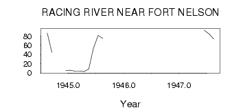
| PointID: | 2762 | Code: | 10BE002 | Latitude (decimal degrees): | 58.82 | Longitude (decimal degrees): | -125.13 | Drainage Area (km2): | 1900.00 | Source: | Hydat | Hydrological Zone: | Mackenzie | Name: | RACING RIVER NEAR FORT NELSON |
|---|
| Download | |
|---|---|
| Site Descriptor Information | Site Time Series Data |
| Link to all available data | |
| ID | Year | Jan | Feb | Mar | Apr | May | Jun | Jul | Aug | Sep | Oct | Nov | Dec |
|---|---|---|---|---|---|---|---|---|---|---|---|---|---|
| 2762 | 1944 | 86.40 | 44.70 | 5.00 | |||||||||
| 2762 | 1945 | 6.00 | 4.00 | 4.00 | 3.00 | 8.60 | 53.20 | 81.30 | 74.70 | ||||
| 2762 | 1947 | 92.50 | 84.70 | 73.60 |
 Return to R-Arctic Net Home Page