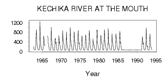
| PointID: | 2758 | Code: | 10BB001 | Latitude (decimal degrees): | 59.61 | Longitude (decimal degrees): | -127.31 | Drainage Area (km2): | 22700.00 | Source: | Hydat | Hydrological Zone: | Mackenzie | Name: | KECHIKA RIVER AT THE MOUTH |
|---|
| Download | |
|---|---|
| Site Descriptor Information | Site Time Series Data |
| Link to all available data | |
| ID | Year | Jan | Feb | Mar | Apr | May | Jun | Jul | Aug | Sep | Oct | Nov | Dec |
|---|---|---|---|---|---|---|---|---|---|---|---|---|---|
| 2758 | 1962 | 197.00 | 110.00 | 76.00 | |||||||||
| 2758 | 1963 | 70.00 | 65.00 | 59.00 | 65.00 | 337.00 | 727.00 | 909.00 | 403.00 | 305.00 | 190.00 | 119.00 | 76.00 |
| 2758 | 1964 | 62.00 | 59.00 | 68.00 | 73.00 | 122.00 | 1250.00 | 599.00 | 407.00 | 225.00 | 180.00 | 93.00 | 62.00 |
| 2758 | 1965 | 48.00 | 46.00 | 47.00 | 124.00 | 306.00 | 647.00 | 473.00 | 274.00 | 288.00 | 221.00 | ||
| 2758 | 1966 | 650.00 | 588.00 | 373.00 | 253.00 | 194.00 | 116.00 | 77.00 | |||||
| 2758 | 1967 | 65.00 | 52.00 | 45.00 | 48.00 | 249.00 | 1000.00 | 537.00 | 339.00 | 257.00 | 219.00 | 101.00 | 76.00 |
| 2758 | 1968 | 47.00 | 41.00 | 43.00 | 52.00 | 265.00 | 552.00 | 545.00 | 320.00 | 388.00 | 201.00 | 98.00 | 66.00 |
| 2758 | 1969 | 41.00 | 35.00 | 35.00 | 73.00 | 295.00 | 661.00 | 341.00 | 400.00 | 322.00 | 171.00 | 78.00 | 71.00 |
| 2758 | 1970 | 56.00 | 50.00 | 45.00 | 56.00 | 163.00 | 866.00 | 515.00 | 416.00 | 342.00 | 293.00 | 116.00 | 68.00 |
| 2758 | 1971 | 53.00 | 48.00 | 45.00 | 52.00 | 265.00 | 821.00 | 427.00 | 283.00 | 213.00 | 153.00 | 82.00 | 62.00 |
| 2758 | 1972 | 40.00 | 27.00 | 26.00 | 39.00 | 289.00 | 1000.00 | 489.00 | 408.00 | 261.00 | 258.00 | 94.00 | 59.00 |
| 2758 | 1973 | 57.00 | 47.00 | 44.00 | 57.00 | 276.00 | 817.00 | 731.00 | 374.00 | 368.00 | 173.00 | 94.00 | 83.00 |
| 2758 | 1974 | 64.00 | 42.00 | 36.00 | 37.00 | 202.00 | 606.00 | 882.00 | 581.00 | 300.00 | 358.00 | 168.00 | 84.00 |
| 2758 | 1975 | 68.00 | 64.00 | 60.00 | 60.00 | 182.00 | 552.00 | 654.00 | 451.00 | 247.00 | 168.00 | 84.00 | 69.00 |
| 2758 | 1976 | 57.00 | 50.00 | 46.00 | 56.00 | 257.00 | 626.00 | 693.00 | 428.00 | 312.00 | 193.00 | 116.00 | 72.00 |
| 2758 | 1977 | 68.00 | 56.00 | 48.00 | 78.00 | 310.00 | 870.00 | 682.00 | 406.00 | 237.00 | 170.00 | 93.00 | 55.00 |
| 2758 | 1978 | 48.00 | 42.00 | 39.00 | 60.00 | 157.00 | 528.00 | 292.00 | 298.00 | 271.00 | 231.00 | 117.00 | 75.00 |
| 2758 | 1979 | 54.00 | 37.00 | 42.00 | 53.00 | 251.00 | 902.00 | 867.00 | 342.00 | 254.00 | 209.00 | 115.00 | 62.00 |
| 2758 | 1980 | 51.00 | 52.00 | 49.00 | 51.00 | 300.00 | 648.00 | 656.00 | 422.00 | 349.00 | 370.00 | 164.00 | 89.00 |
| 2758 | 1981 | 69.00 | 58.00 | 60.00 | 60.00 | 573.00 | 905.00 | 586.00 | 309.00 | 299.00 | 210.00 | 136.00 | 59.00 |
| 2758 | 1982 | 44.00 | 45.00 | 49.00 | 53.00 | 160.00 | 965.00 | 510.00 | 325.00 | 314.00 | 206.00 | 118.00 | 72.00 |
| 2758 | 1983 | 59.00 | 57.00 | 53.00 | 60.00 | 232.00 | 734.00 | 425.00 | 328.00 | 265.00 | 177.00 | 107.00 | 57.00 |
| 2758 | 1984 | 44.00 | 42.00 | 47.00 | 66.00 | 176.00 | 736.00 | 605.00 | 530.00 | 351.00 | 199.00 | 134.00 | 110.00 |
| 2758 | 1985 | 58.00 | 42.00 | 46.00 | 63.00 | 298.00 | 672.00 | 842.00 | 330.00 | 396.00 | 267.00 | 105.00 | 66.00 |
| 2758 | 1991 | 50.00 | 49.00 | 49.00 | 91.00 | 400.00 | 618.00 | 475.00 | 293.00 | 366.00 | 269.00 | 100.00 | 78.00 |
| 2758 | 1992 | 61.00 | 56.00 | 76.00 | 97.00 | 221.00 | 986.00 | 493.00 | 257.00 | 189.00 | 226.00 | 107.00 | 61.00 |
| 2758 | 1993 | 49.00 | 51.00 | 50.00 | 80.00 | 468.00 | 721.00 | 482.00 | 295.00 | 179.00 | 174.00 | 108.00 | 64.00 |
| Other Close Sites | ||||||
|---|---|---|---|---|---|---|
| PointID | Latitude | Longitude | Drainage Area | Source | Name | |
| 2765 | 59.70 | -127.22 | 61600.00 | Hydat | LIARD RIVER ABOVE KECHIKA RIVER | |
 Return to R-Arctic Net Home Page