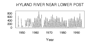
| PointID: | 2756 | Code: | 10AD001 | Latitude (decimal degrees): | 59.95 | Longitude (decimal degrees): | -128.15 | Drainage Area (km2): | 9450.00 | Source: | Hydat | Hydrological Zone: | Mackenzie | Name: | HYLAND RIVER NEAR LOWER POST |
|---|
| Download | |
|---|---|
| Site Descriptor Information | Site Time Series Data |
| Link to all available data | |
| ID | Year | Jan | Feb | Mar | Apr | May | Jun | Jul | Aug | Sep | Oct | Nov | Dec |
|---|---|---|---|---|---|---|---|---|---|---|---|---|---|
| 2756 | 1947 | 31.00 | 240.00 | 647.00 | 123.00 | 135.00 | 44.00 | ||||||
| 2756 | 1949 | 494.00 | 297.00 | 134.00 | 60.90 | 28.00 | 32.00 | ||||||
| 2756 | 1950 | 27.00 | 23.00 | 20.00 | 52.00 | 99.60 | 94.10 | 47.00 | |||||
| 2756 | 1951 | 78.70 | |||||||||||
| 2756 | 1952 | 418.00 | 337.00 | 133.00 | 155.00 | 131.00 | 38.00 | ||||||
| 2756 | 1953 | 81.00 | 437.00 | 264.00 | 218.00 | 163.00 | 136.00 | 76.40 | |||||
| 2756 | 1954 | 309.00 | 524.00 | 292.00 | 161.00 | 121.00 | 82.20 | 19.00 | |||||
| 2756 | 1955 | 89.20 | 499.00 | 432.00 | 209.00 | 112.00 | 60.60 | ||||||
| 2756 | 1956 | 201.00 | 495.00 | 304.00 | 133.00 | 105.00 | 53.60 | ||||||
| 2756 | 1957 | 303.00 | 207.00 | 87.10 | 51.30 | 37.00 | 22.00 | ||||||
| 2756 | 1958 | 20.00 | 18.00 | 16.00 | 24.00 | 112.00 | 304.00 | 153.00 | 115.00 | 113.00 | 85.20 | 38.00 | 24.00 |
| 2756 | 1959 | 23.00 | 17.00 | 14.00 | 16.00 | 217.00 | 545.00 | 296.00 | 257.00 | 140.00 | 86.00 | 40.00 | 19.00 |
| 2756 | 1960 | 19.00 | 20.00 | 17.00 | 23.00 | 243.00 | 535.00 | 329.00 | 181.00 | 165.00 | 88.90 | 41.00 | 30.00 |
| 2756 | 1961 | 30.00 | 22.00 | 18.00 | 22.00 | 287.00 | 630.00 | 236.00 | 128.00 | 116.00 | 120.00 | 43.00 | 29.00 |
| 2756 | 1962 | 29.00 | 29.00 | 23.00 | 18.00 | 179.00 | 898.00 | 614.00 | 275.00 | 149.00 | 122.00 | 59.00 | 45.00 |
| 2756 | 1963 | 39.00 | 32.00 | 28.00 | 31.00 | 239.00 | 522.00 | 468.00 | 141.00 | 164.00 | 114.00 | 76.00 | 42.00 |
| 2756 | 1964 | 31.00 | 24.00 | 24.00 | 26.00 | 86.10 | 721.00 | ||||||
| 2756 | 1965 | 107.00 | 43.00 | 23.00 | |||||||||
| 2756 | 1966 | 18.00 | 16.00 | 16.00 | 20.00 | 138.00 | 439.00 | 288.00 | 180.00 | 114.00 | 114.00 | 69.00 | 39.00 |
| 2756 | 1967 | 29.00 | 23.00 | 20.00 | 20.00 | 182.00 | 594.00 | 259.00 | 146.00 | 124.00 | 98.10 | 39.00 | 25.00 |
| 2756 | 1968 | 23.00 | 21.00 | 20.00 | 20.00 | 183.00 | 537.00 | 443.00 | 243.00 | 225.00 | 120.00 | 56.00 | 43.00 |
| 2756 | 1969 | 24.00 | 15.00 | 15.00 | 28.00 | 153.00 | 376.00 | 208.00 | 232.00 | 190.00 | 98.40 | 48.00 | 36.00 |
| 2756 | 1970 | 27.00 | 23.00 | 21.00 | 21.00 | 192.00 | 462.00 | 353.00 | 232.00 | 176.00 | 156.00 | 66.00 | 41.00 |
| 2756 | 1971 | 28.00 | 20.00 | 17.00 | 19.00 | 172.00 | 621.00 | 252.00 | 123.00 | 107.00 | 84.40 | 55.00 | 27.00 |
| 2756 | 1972 | 18.00 | 17.00 | 14.00 | 16.00 | 201.00 | 719.00 | 351.00 | 217.00 | 114.00 | 66.70 | 37.00 | 26.00 |
| 2756 | 1973 | 20.00 | 18.00 | 17.00 | 20.00 | 229.00 | 550.00 | 288.00 | 162.00 | 154.00 | 72.10 | 32.00 | 27.00 |
| 2756 | 1974 | 21.00 | 14.00 | 13.00 | 22.00 | 184.00 | 493.00 | 343.00 | 271.00 | 126.00 | 96.00 | 59.00 | 39.00 |
| 2756 | 1975 | 29.00 | 24.00 | 22.00 | 27.00 | 201.00 | 641.00 | 430.00 | 174.00 | 126.00 | 102.00 | 63.00 | 35.00 |
| 2756 | 1976 | 23.00 | 20.00 | 19.00 | 26.00 | 255.00 | 560.00 | 478.00 | 180.00 | 111.00 | 72.60 | 42.00 | 29.00 |
| 2756 | 1977 | 26.00 | 23.00 | 21.00 | 24.00 | 254.00 | 545.00 | 291.00 | 181.00 | 132.00 | 86.40 | 44.00 | 27.00 |
| 2756 | 1978 | 23.00 | 19.00 | 16.00 | 19.00 | 112.00 | 328.00 | 293.00 | 164.00 | 102.00 | 130.00 | 66.00 | 41.00 |
| 2756 | 1979 | 25.00 | 21.00 | 20.00 | 19.00 | 162.00 | 577.00 | 439.00 | 184.00 | 115.00 | 99.50 | 61.00 | 32.00 |
| 2756 | 1980 | 21.00 | 20.00 | 17.00 | 28.00 | 197.00 | 382.00 | 220.00 | 169.00 | 128.00 | 159.00 | 64.00 | 28.00 |
| 2756 | 1981 | 27.00 | 25.00 | 22.00 | 21.00 | 317.00 | 406.00 | 215.00 | 107.00 | 132.00 | 77.10 | 49.00 | 32.00 |
| 2756 | 1982 | 21.00 | 13.00 | 8.00 | 16.00 | 133.00 | 409.00 | 188.00 | 117.00 | 93.80 | 71.50 | 46.00 | 31.00 |
| 2756 | 1984 | 16.00 | 13.00 | 10.00 | 26.00 | 163.00 | 479.00 | 271.00 | 172.00 | 114.00 | 68.10 | 42.00 | 30.00 |
| 2756 | 1985 | 22.00 | 18.00 | 17.00 | 16.00 | 119.00 | 494.00 | 365.00 | 153.00 | 106.00 | 64.60 | 24.00 | 23.00 |
| 2756 | 1986 | 23.00 | 19.00 | 16.00 | 18.00 | 133.00 | 529.00 | 455.00 | 179.00 | 107.00 | 105.00 | 50.00 | 34.00 |
| 2756 | 1987 | 24.00 | 21.00 | 18.00 | 21.00 | 163.00 | 487.00 | 329.00 | 168.00 | 142.00 | 112.00 | 47.00 | 46.00 |
| 2756 | 1988 | 34.00 | 24.00 | 20.00 | 23.00 | 357.00 | 611.00 | 506.00 | 198.00 | 166.00 | 129.00 | 61.00 | 44.00 |
| 2756 | 1989 | 34.00 | 26.00 | 22.00 | 29.00 | 232.00 | 400.00 | 178.00 | 105.00 | 70.00 | 66.00 | 36.00 | 32.00 |
| 2756 | 1990 | 26.00 | 22.00 | 20.00 | 28.00 | 205.00 | 563.00 | 251.00 | 138.00 | 151.00 | 98.10 | 47.00 | 45.00 |
| 2756 | 1991 | 37.00 | 30.00 | 24.00 | 42.00 | 294.00 | 509.00 | 344.00 | 195.00 | 172.00 | 120.00 | 63.00 | 43.00 |
| 2756 | 1992 | 35.00 | 32.00 | 27.00 | 25.00 | 135.00 | 786.00 | 452.00 | 199.00 | 125.00 | 79.50 | 36.00 | 32.00 |
| 2756 | 1993 | 20.00 | 16.00 | 13.00 | 22.00 | 267.00 | 468.00 | 247.00 | 129.00 | 98.10 | 77.90 | 17.00 | 19.00 |
 Return to R-Arctic Net Home Page