| PointID: | 2755 | Code: | 10AC006 | Latitude (decimal degrees): | 59.85 | Longitude (decimal degrees): | -128.59 | Drainage Area (km2): | 14500.00 | Source: | Hydat | Hydrological Zone: | Mackenzie | Name: | DEASE RIVER NEAR THE MOUTH |
|---|
| Download | |
|---|---|
| Site Descriptor Information | Site Time Series Data |
| Link to all available data | |
| ID | Year | Jan | Feb | Mar | Apr | May | Jun | Jul | Aug | Sep | Oct | Nov | Dec |
|---|---|---|---|---|---|---|---|---|---|---|---|---|---|
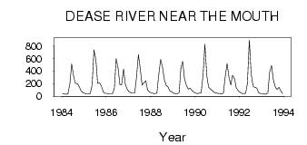
| 2755 | 1984 | 37.00 | 32.00 | 29.00 | 38.00 | 208.00 | 511.00 | 315.00 | 205.00 | 201.00 | 156.00 | 86.00 | 57.00 |
| 2755 | 1985 | 43.00 | 35.00 | 35.00 | 41.00 | 178.00 | 737.00 | 582.00 | 205.00 | 212.00 | 163.00 | 70.00 | 45.00 |
| 2755 | 1986 | 44.00 | 34.00 | 34.00 | 32.00 | 132.00 | 600.00 | 442.00 | 188.00 | 181.00 | 434.00 | 186.00 | 109.00 |
| 2755 | 1987 | 67.00 | 53.00 | 50.00 | 51.00 | 286.00 | 663.00 | 455.00 | 181.00 | 212.00 | 247.00 | 99.00 | 64.00 |
| 2755 | 1988 | 53.00 | 45.00 | 40.00 | 46.00 | 330.00 | 585.00 | 476.00 | 266.00 | 175.00 | 145.00 | 85.00 | 67.00 |
| 2755 | 1989 | 47.00 | 42.00 | 38.00 | 56.00 | 447.00 | 554.00 | 266.00 | 173.00 | 111.00 | 127.00 | 90.00 | 66.00 |
| 2755 | 1990 | 47.00 | 41.00 | 47.00 | 53.00 | 348.00 | 827.00 | 324.00 | 142.00 | 110.00 | 87.50 | 57.00 | 52.00 |
| 2755 | 1991 | 44.00 | 40.00 | 34.00 | 50.00 | 327.00 | 520.00 | 293.00 | 178.00 | 333.00 | 275.00 | 133.00 | 87.00 |
| 2755 | 1992 | 62.00 | 44.00 | 39.00 | 43.00 | 201.00 | 899.00 | 371.00 | 157.00 | 137.00 | 130.00 | 58.00 | 39.00 |
| 2755 | 1993 | 39.00 | 33.00 | 29.00 | 51.00 | 381.00 | 487.00 | 267.00 | 146.00 | 106.00 | 140.00 | 85.00 | 39.00 |
| Other Close Sites | ||||||
|---|---|---|---|---|---|---|
| PointID | Latitude | Longitude | Drainage Area | Source | Name | |
| 5839 | 60.05 | -128.90 | 33400.00 | Hydat | LIARD RIVER AT UPPER CROSSING | |
 Return to R-Arctic Net Home Page