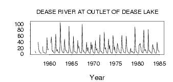
| PointID: | 2752 | Code: | 10AC003 | Latitude (decimal degrees): | 58.81 | Longitude (decimal degrees): | -130.08 | Drainage Area (km2): | 1520.00 | Source: | Hydat | Hydrological Zone: | Mackenzie | Name: | DEASE RIVER AT OUTLET OF DEASE LAKE |
|---|
| Download | |
|---|---|
| Site Descriptor Information | Site Time Series Data |
| Link to all available data | |
| ID | Year | Jan | Feb | Mar | Apr | May | Jun | Jul | Aug | Sep | Oct | Nov | Dec |
|---|---|---|---|---|---|---|---|---|---|---|---|---|---|
| 2752 | 1956 | 8.49 | 5.00 | 3.00 | |||||||||
| 2752 | 1957 | 38.20 | 19.60 | 12.30 | 8.37 | 6.44 | 5.00 | 3.00 | |||||
| 2752 | 1958 | 2.00 | 2.00 | 2.00 | 24.50 | 8.81 | 5.43 | 4.91 | 4.98 | 4.00 | 3.00 | ||
| 2752 | 1959 | 2.00 | 2.00 | 3.00 | 3.00 | 24.00 | 53.70 | 22.10 | 13.70 | 13.80 | 15.80 | ||
| 2752 | 1960 | 36.80 | 56.80 | 37.60 | 13.20 | 8.42 | 11.00 | 9.00 | 5.00 | ||||
| 2752 | 1961 | 4.00 | 3.00 | 3.00 | 3.00 | 35.40 | 65.10 | 26.20 | 10.70 | 9.28 | 14.80 | 13.00 | 7.00 |
| 2752 | 1962 | 6.00 | 4.00 | 3.00 | 3.00 | 11.30 | 104.00 | 86.40 | 28.10 | 24.60 | 14.20 | 10.00 | 7.00 |
| 2752 | 1963 | 5.00 | 4.00 | 4.00 | 3.00 | 30.00 | 48.60 | 27.70 | 13.40 | 11.40 | 12.60 | 8.00 | 6.00 |
| 2752 | 1964 | 5.00 | 4.00 | 3.00 | 3.00 | 5.41 | 91.70 | 35.30 | 24.90 | 16.50 | 10.20 | 6.00 | 4.00 |
| 2752 | 1965 | 3.00 | 3.00 | 2.00 | 2.00 | 16.10 | 58.90 | 23.00 | 8.61 | 8.70 | 8.31 | 7.00 | 4.00 |
| 2752 | 1966 | 3.00 | 3.00 | 3.00 | 2.00 | 16.10 | 44.30 | 18.40 | 24.40 | 24.70 | 19.40 | 9.00 | 6.00 |
| 2752 | 1967 | 5.00 | 4.00 | 3.00 | 3.00 | 23.30 | 98.70 | 29.60 | 12.30 | 8.56 | 10.80 | 7.00 | 4.00 |
| 2752 | 1968 | 4.00 | 3.00 | 2.00 | 2.00 | 12.20 | 38.90 | 18.80 | 9.57 | 21.10 | 20.10 | 9.00 | 5.00 |
| 2752 | 1969 | 4.00 | 3.00 | 2.00 | 2.00 | 20.10 | 38.70 | 14.60 | 23.10 | 31.00 | 16.40 | 9.00 | 6.00 |
| 2752 | 1970 | 4.00 | 3.00 | 2.00 | 2.00 | 16.00 | 44.40 | 19.40 | 13.70 | 12.70 | 18.00 | 10.00 | 5.00 |
| 2752 | 1971 | 4.00 | 3.00 | 3.00 | 2.00 | 24.40 | 63.20 | 22.20 | 8.46 | 8.45 | 8.97 | 6.00 | 4.00 |
| 2752 | 1972 | 3.00 | 2.00 | 2.00 | 2.00 | 23.30 | 72.60 | 23.00 | 15.40 | 17.60 | 21.40 | 12.00 | 7.00 |
| 2752 | 1973 | 4.00 | 3.00 | 3.00 | 2.00 | 27.10 | 49.30 | 29.40 | 15.50 | 28.90 | 16.20 | 7.00 | 6.00 |
| 2752 | 1974 | 4.00 | 3.00 | 2.00 | 2.00 | 20.60 | 61.30 | 49.40 | 25.10 | 12.50 | 23.90 | 17.00 | 7.00 |
| 2752 | 1975 | 6.00 | 4.00 | 3.00 | 3.00 | 18.70 | 35.20 | 28.00 | 17.40 | 17.50 | 12.90 | 7.00 | 5.00 |
| 2752 | 1976 | 4.00 | 4.00 | 3.00 | 2.00 | 28.80 | 61.90 | 39.90 | 18.20 | 16.50 | 11.30 | 7.00 | 5.00 |
| 2752 | 1977 | 4.00 | 4.00 | 3.00 | 4.00 | 30.80 | 58.70 | 33.30 | 16.40 | 10.90 | 8.85 | 5.00 | 4.00 |
| 2752 | 1978 | 3.00 | 2.00 | 2.00 | 2.00 | 10.70 | 18.90 | 9.26 | 6.10 | 7.26 | 8.73 | 7.00 | 5.00 |
| 2752 | 1979 | 4.00 | 3.00 | 3.00 | 2.00 | 29.50 | 89.80 | 38.60 | 14.10 | 8.45 | 9.15 | 5.00 | 4.00 |
| 2752 | 1980 | 3.00 | 3.00 | 2.00 | 2.00 | 27.90 | 31.00 | 29.70 | 35.10 | 21.90 | 22.50 | 12.00 | 7.00 |
| 2752 | 1981 | 6.00 | 4.00 | 4.00 | 3.00 | 54.80 | 79.80 | 35.00 | 11.80 | 10.90 | 14.20 | 14.00 | 8.00 |
| 2752 | 1982 | 5.00 | 4.00 | 3.00 | 3.00 | 11.80 | 80.90 | 24.10 | 9.98 | 10.70 | 9.77 | 7.00 | 5.00 |
| 2752 | 1983 | 4.00 | 3.00 | 2.00 | 2.00 | 16.80 | 31.30 | 24.00 | 16.20 | 17.80 | 14.70 | 8.00 | 5.00 |
| 2752 | 1984 | 3.00 | 2.00 | 2.00 | 2.00 | 17.50 | 38.70 | 25.90 | 12.00 | 11.30 | 11.20 | 7.00 | 5.00 |
 Return to R-Arctic Net Home Page