| PointID: | 2749 | Code: | 09AE003 | Latitude (decimal degrees): | 59.93 | Longitude (decimal degrees): | -131.76 | Drainage Area (km2): | 3320.00 | Source: | Hydat | Hydrological Zone: | Yukon | Name: | SWIFT RIVER NEAR SWIFT RIVER |
|---|
| Download | |
|---|---|
| Site Descriptor Information | Site Time Series Data |
| Link to all available data | |
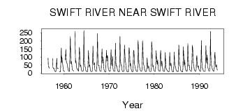
| ID | Year | Jan | Feb | Mar | Apr | May | Jun | Jul | Aug | Sep | Oct | Nov | Dec |
|---|---|---|---|---|---|---|---|---|---|---|---|---|---|
| 2749 | 1956 | 92.90 | 37.80 | 39.00 | 27.70 | ||||||||
| 2749 | 1957 | 89.40 | 34.90 | 27.80 | 29.50 | 27.00 | 17.00 | ||||||
| 2749 | 1958 | 12.00 | 9.00 | 8.00 | 10.00 | 57.40 | 91.40 | 33.90 | 26.80 | 28.30 | 29.10 | ||
| 2749 | 1959 | 8.00 | 7.00 | 6.00 | 8.00 | 63.40 | 156.00 | 64.20 | 96.80 | 64.00 | 50.50 | 27.00 | 16.00 |
| 2749 | 1960 | 12.00 | 10.00 | 8.00 | 81.20 | 147.00 | 94.80 | 63.90 | 62.80 | 54.10 | 36.00 | 24.00 | |
| 2749 | 1961 | 16.00 | 11.00 | 9.00 | 10.00 | 99.60 | 226.00 | 111.00 | 57.60 | 71.30 | 50.50 | 22.00 | 19.00 |
| 2749 | 1962 | 17.00 | 15.00 | 12.00 | 260.00 | 163.00 | 62.40 | 77.70 | 50.00 | 30.00 | 27.00 | ||
| 2749 | 1963 | 21.00 | 21.00 | 14.00 | 11.00 | 76.50 | 161.00 | 121.00 | 38.90 | 49.20 | 46.40 | 24.00 | 15.00 |
| 2749 | 1964 | 13.00 | 11.00 | 11.00 | 10.00 | 27.00 | 265.00 | 87.20 | 48.40 | 39.30 | 34.90 | 18.00 | 12.00 |
| 2749 | 1965 | 10.00 | 8.00 | 7.00 | 7.00 | 45.40 | 140.00 | 85.30 | 37.20 | 52.20 | 42.40 | 22.00 | 12.00 |
| 2749 | 1966 | 9.00 | 8.00 | 8.00 | 8.00 | 33.70 | 167.00 | 74.90 | 59.80 | 49.90 | 63.80 | 23.00 | 16.00 |
| 2749 | 1967 | 13.00 | 12.00 | 10.00 | 11.00 | 67.30 | 245.00 | 97.70 | 47.90 | 47.60 | 47.40 | 24.00 | 20.00 |
| 2749 | 1968 | 12.00 | 10.00 | 10.00 | 10.00 | 75.70 | 150.00 | 100.00 | 61.70 | 98.60 | 55.30 | 25.00 | 18.00 |
| 2749 | 1969 | 11.00 | 6.00 | 5.00 | 8.00 | 76.80 | 141.00 | 76.00 | 108.00 | 105.00 | 44.10 | 25.00 | 19.00 |
| 2749 | 1970 | 13.00 | 11.00 | 11.00 | 12.00 | 55.50 | 145.00 | 76.70 | 45.70 | 69.60 | 104.00 | 32.00 | 19.00 |
| 2749 | 1971 | 12.00 | 12.00 | 10.00 | 11.00 | 50.00 | 186.00 | 63.10 | 42.50 | 45.90 | 35.50 | 21.00 | 14.00 |
| 2749 | 1972 | 9.00 | 8.00 | 7.00 | 7.00 | 68.00 | 227.00 | 86.00 | 56.10 | 47.60 | 49.30 | 22.00 | 13.00 |
| 2749 | 1973 | 8.00 | 8.00 | 9.00 | 12.00 | 61.00 | 174.00 | 104.00 | 76.20 | 65.90 | 33.20 | 17.00 | 12.00 |
| 2749 | 1974 | 7.00 | 7.00 | 6.00 | 7.00 | 61.80 | 158.00 | 146.00 | 87.00 | 43.40 | 60.40 | 32.00 | 20.00 |
| 2749 | 1975 | 12.00 | 8.00 | 6.00 | 7.00 | 48.10 | 142.00 | 132.00 | 56.50 | 48.60 | 38.10 | 21.00 | 16.00 |
| 2749 | 1976 | 14.00 | 11.00 | 9.00 | 8.00 | 48.00 | 203.00 | 149.00 | 60.10 | 51.00 | 38.00 | 25.00 | 14.00 |
| 2749 | 1977 | 14.00 | 13.00 | 10.00 | 16.00 | 72.90 | 200.00 | 118.00 | 54.40 | 50.90 | 40.30 | 21.00 | 13.00 |
| 2749 | 1978 | 11.00 | 9.00 | 8.00 | 9.00 | 28.90 | 94.00 | 43.00 | 29.40 | 31.40 | 43.50 | 27.00 | 15.00 |
| 2749 | 1979 | 11.00 | 8.00 | 8.00 | 9.00 | 55.50 | 194.00 | 155.00 | 50.40 | 38.50 | 48.30 | 23.00 | 16.00 |
| 2749 | 1980 | 13.00 | 11.00 | 9.00 | 10.00 | 65.30 | 139.00 | 69.30 | 72.40 | 52.30 | 82.40 | 35.00 | 17.00 |
| 2749 | 1981 | 15.00 | 12.00 | 12.00 | 11.00 | 111.00 | 140.00 | 73.80 | 43.10 | 74.10 | 52.60 | 27.00 | 15.00 |
| 2749 | 1982 | 10.00 | 11.00 | 9.00 | 9.00 | 29.00 | 128.00 | 65.30 | 31.80 | 26.60 | 21.20 | 17.00 | 13.00 |
| 2749 | 1983 | 10.00 | 8.00 | 7.00 | 8.00 | 47.00 | 128.00 | 58.40 | 43.90 | 63.70 | 44.50 | 21.00 | 13.00 |
| 2749 | 1984 | 8.00 | 6.00 | 6.00 | 9.00 | 52.40 | 131.00 | 69.80 | 44.30 | 39.10 | 30.50 | 19.00 | 13.00 |
| 2749 | 1985 | 11.00 | 9.00 | 9.00 | 8.00 | 47.50 | 174.00 | 131.00 | 48.20 | 47.90 | 38.60 | 17.00 | 14.00 |
| 2749 | 1986 | 11.00 | 6.00 | 6.00 | 7.00 | 31.90 | 164.00 | 125.00 | 55.80 | 48.30 | 79.90 | 34.00 | 19.00 |
| 2749 | 1987 | 15.00 | 13.00 | 10.00 | 12.00 | 58.00 | 184.00 | 111.00 | 44.50 | 44.00 | 47.20 | 21.00 | 17.00 |
| 2749 | 1988 | 13.00 | 12.00 | 11.00 | 15.00 | 88.00 | 173.00 | 155.00 | 77.50 | 47.60 | 42.50 | 25.00 | 16.00 |
| 2749 | 1989 | 12.00 | 10.00 | 10.00 | 23.00 | 100.00 | 109.00 | 56.90 | 42.60 | 35.90 | 44.70 | 25.00 | 21.00 |
| 2749 | 1990 | 15.00 | 12.00 | 10.00 | 14.00 | 91.30 | 202.00 | 80.70 | 33.70 | 29.00 | 24.80 | 14.00 | 12.00 |
| 2749 | 1991 | 11.00 | 10.00 | 9.00 | 14.00 | 94.70 | 170.00 | 79.20 | 60.00 | 112.00 | 90.60 | 38.00 | 25.00 |
| 2749 | 1992 | 16.00 | 12.00 | 12.00 | 14.00 | 51.20 | 259.00 | 109.00 | 50.80 | 44.50 | 39.30 | 24.00 | 19.00 |
| 2749 | 1993 | 14.00 | 11.00 | 10.00 | 30.00 | 110.00 | 129.00 | 63.30 | 37.00 | 40.60 | 53.00 | 34.00 | 18.00 |
 Return to R-Arctic Net Home Page