| PointID: | 265 | Code: | 05BF016 | Latitude (decimal degrees): | 50.95 | Longitude (decimal degrees): | -115.15 | Drainage Area (km2): | 9.39 | Source: | Hydat | Hydrological Zone: | Nelson | Name: | MARMOT CREEK MAIN STEM NEAR SEEBE |
|---|
| Download | |
|---|---|
| Site Descriptor Information | Site Time Series Data |
| Link to all available data | |
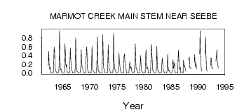
| ID | Year | Jan | Feb | Mar | Apr | May | Jun | Jul | Aug | Sep | Oct | Nov | Dec |
|---|---|---|---|---|---|---|---|---|---|---|---|---|---|
| 265 | 1962 | 0.17 | 0.49 | 0.21 | 0.08 | 0.13 | 0.06 | 0.00 | 0.00 | ||||
| 265 | 1963 | 0.00 | 0.00 | 0.00 | 0.00 | 0.17 | 0.59 | 0.46 | 0.13 | 0.07 | 0.04 | 0.00 | 0.00 |
| 265 | 1964 | 0.00 | 0.00 | 0.00 | 0.00 | 0.16 | 0.95 | 0.31 | 0.07 | 0.08 | 0.08 | 0.00 | 0.00 |
| 265 | 1965 | 0.00 | 0.00 | 0.00 | 0.00 | 0.11 | 0.66 | 0.45 | 0.19 | 0.14 | 0.20 | 0.00 | 0.00 |
| 265 | 1966 | 0.00 | 0.00 | 0.00 | 0.00 | 0.29 | 0.57 | 0.29 | 0.10 | 0.05 | 0.04 | 0.00 | 0.00 |
| 265 | 1967 | 0.00 | 0.00 | 0.00 | 0.00 | 0.17 | 0.80 | 0.31 | 0.08 | 0.03 | 0.03 | 0.00 | 0.00 |
| 265 | 1968 | 0.00 | 0.00 | 0.00 | 0.00 | 0.14 | 0.53 | 0.27 | 0.13 | 0.10 | 0.08 | 0.00 | 0.00 |
| 265 | 1969 | 0.00 | 0.00 | 0.00 | 0.00 | 0.35 | 0.59 | 0.47 | 0.09 | 0.04 | 0.03 | 0.00 | 0.00 |
| 265 | 1970 | 0.00 | 0.00 | 0.00 | 0.00 | 0.13 | 0.61 | 0.19 | 0.06 | 0.04 | 0.03 | 0.00 | 0.00 |
| 265 | 1971 | 0.00 | 0.00 | 0.00 | 0.00 | 0.29 | 0.82 | 0.22 | 0.07 | 0.03 | 0.03 | 0.00 | 0.00 |
| 265 | 1972 | 0.00 | 0.00 | 0.00 | 0.00 | 0.23 | 0.87 | 0.33 | 0.12 | 0.07 | 0.05 | 0.00 | 0.00 |
| 265 | 1973 | 0.00 | 0.00 | 0.00 | 0.00 | 0.22 | 0.64 | 0.26 | 0.08 | 0.08 | 0.04 | 0.00 | 0.00 |
| 265 | 1974 | 0.00 | 0.00 | 0.00 | 0.00 | 0.14 | 0.91 | 0.30 | 0.12 | 0.08 | 0.06 | 0.00 | 0.00 |
| 265 | 1975 | 0.00 | 0.00 | 0.00 | 0.00 | 0.09 | 0.45 | 0.27 | 0.14 | 0.08 | 0.04 | 0.00 | 0.00 |
| 265 | 1976 | 0.00 | 0.00 | 0.00 | 0.00 | 0.37 | 0.43 | 0.27 | 0.20 | 0.16 | 0.07 | 0.00 | 0.00 |
| 265 | 1977 | 0.00 | 0.00 | 0.00 | 0.00 | 0.17 | 0.25 | 0.09 | 0.14 | 0.12 | 0.07 | 0.00 | 0.00 |
| 265 | 1978 | 0.00 | 0.00 | 0.00 | 0.00 | 0.17 | 0.66 | 0.28 | 0.10 | 0.08 | 0.07 | 0.00 | 0.00 |
| 265 | 1979 | 0.00 | 0.00 | 0.00 | 0.00 | 0.17 | 0.39 | 0.14 | 0.05 | 0.03 | 0.02 | 0.00 | 0.00 |
| 265 | 1980 | 0.00 | 0.00 | 0.00 | 0.00 | 0.34 | 0.53 | 0.11 | 0.09 | 0.13 | 0.10 | 0.00 | 0.00 |
| 265 | 1981 | 0.00 | 0.00 | 0.00 | 0.00 | 0.48 | 0.65 | 0.41 | 0.19 | 0.06 | 0.03 | 0.00 | 0.00 |
| 265 | 1982 | 0.00 | 0.00 | 0.00 | 0.00 | 0.11 | 0.60 | 0.21 | 0.06 | 0.05 | 0.05 | 0.00 | 0.00 |
| 265 | 1983 | 0.00 | 0.00 | 0.00 | 0.00 | 0.19 | 0.34 | 0.24 | 0.07 | 0.04 | 0.03 | 0.00 | 0.00 |
| 265 | 1984 | 0.00 | 0.00 | 0.00 | 0.00 | 0.09 | 0.43 | 0.16 | 0.05 | 0.04 | 0.06 | 0.00 | 0.00 |
| 265 | 1985 | 0.00 | 0.00 | 0.00 | 0.00 | 0.23 | 0.30 | 0.10 | 0.15 | 0.23 | 0.10 | 0.00 | 0.00 |
| 265 | 1986 | 0.00 | 0.00 | 0.00 | 0.00 | 0.28 | 0.52 | 0.21 | 0.12 | 0.07 | 0.13 | 0.00 | 0.00 |
| 265 | 1987 | 0.00 | 0.00 | 0.00 | 0.00 | 0.29 | 0.22 | 0.14 | 0.17 | 0.09 | 0.04 | ||
| 265 | 1988 | 0.28 | 0.37 | 0.12 | 0.12 | 0.10 | 0.11 | ||||||
| 265 | 1989 | 0.24 | 0.42 | 0.17 | 0.14 | 0.22 | 0.09 | ||||||
| 265 | 1990 | 0.43 | 0.96 | 0.38 | 0.16 | 0.06 | 0.04 | ||||||
| 265 | 1991 | 0.41 | 0.82 | 0.43 | 0.09 | 0.05 | 0.04 | ||||||
| 265 | 1992 | 0.16 | 0.34 | 0.34 | 0.11 | 0.12 | 0.09 | ||||||
| 265 | 1993 | 0.27 | 0.37 | 0.53 | 0.27 | 0.21 | 0.11 |
 Return to R-Arctic Net Home Page