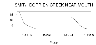
| PointID: | 260 | Code: | 05BF008 | Latitude (decimal degrees): | 50.68 | Longitude (decimal degrees): | -115.14 | Drainage Area (km2): | 131.00 | Source: | Hydat | Hydrological Zone: | Nelson | Name: | SMITH-DORRIEN CREEK NEAR MOUTH |
|---|
| Download | |
|---|---|
| Site Descriptor Information | Site Time Series Data |
| Link to all available data | |
| ID | Year | Jan | Feb | Mar | Apr | May | Jun | Jul | Aug | Sep | Oct | Nov | Dec |
|---|---|---|---|---|---|---|---|---|---|---|---|---|---|
| 260 | 1932 | 17.10 | 6.92 | 4.46 | 2.84 | 1.24 | |||||||
| 260 | 1933 | 12.80 | 9.80 | 4.90 | 2.25 | 1.38 |
 Return to R-Arctic Net Home Page