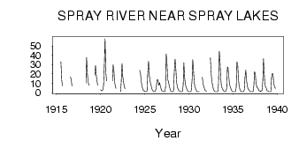
| PointID: | 239 | Code: | 05BC002 | Latitude (decimal degrees): | 50.88 | Longitude (decimal degrees): | -115.36 | Drainage Area (km2): | 360.00 | Source: | Hydat | Hydrological Zone: | Nelson | Name: | SPRAY RIVER NEAR SPRAY LAKES |
|---|
| Download | |
|---|---|
| Site Descriptor Information | Site Time Series Data |
| Link to all available data | |
| ID | Year | Jan | Feb | Mar | Apr | May | Jun | Jul | Aug | Sep | Oct | Nov | Dec |
|---|---|---|---|---|---|---|---|---|---|---|---|---|---|
| 239 | 1915 | 32.90 | 13.20 | 7.18 | |||||||||
| 239 | 1916 | 16.80 | 13.70 | 6.87 | |||||||||
| 239 | 1917 | 12.70 | |||||||||||
| 239 | 1918 | 10.40 | 37.50 | 19.70 | 11.70 | 7.60 | |||||||
| 239 | 1919 | 18.80 | 29.20 | 17.70 | 12.70 | 7.93 | |||||||
| 239 | 1920 | 3.00 | 2.00 | 2.00 | 3.00 | 7.90 | 33.20 | 57.70 | 20.70 | 12.50 | |||
| 239 | 1921 | 12.70 | 29.80 | 22.70 | 11.60 | 5.94 | 4.76 | ||||||
| 239 | 1922 | 1.00 | 10.30 | 31.20 | 18.10 | 11.70 | 7.18 | 4.23 | |||||
| 239 | 1924 | 24.00 | 20.00 | 12.70 | 6.91 | 4.38 | 2.00 | 2.00 | |||||
| 239 | 1925 | 1.00 | 1.00 | 1.00 | 2.00 | 21.20 | 33.70 | 19.60 | 12.70 | 9.24 | 5.74 | 3.00 | 2.00 |
| 239 | 1926 | 1.00 | 1.00 | 1.00 | 4.00 | 9.52 | 14.10 | 13.00 | 7.77 | 10.50 | 7.73 | 4.00 | 2.00 |
| 239 | 1927 | 2.00 | 1.00 | 1.00 | 1.00 | 5.34 | 41.40 | 30.40 | 13.80 | 11.80 | 7.58 | 5.00 | 2.00 |
| 239 | 1928 | 1.00 | 1.00 | 1.00 | 2.00 | 22.60 | 35.80 | 27.00 | 11.80 | 6.30 | 4.08 | 2.00 | 2.00 |
| 239 | 1929 | 1.00 | 1.00 | 1.00 | 1.00 | 8.16 | 32.10 | 15.90 | 9.15 | 5.63 | 3.71 | 2.00 | 1.00 |
| 239 | 1930 | 1.00 | 1.00 | 1.00 | 2.00 | 13.90 | 35.20 | 26.20 | 11.20 | 6.54 | 4.07 | 2.00 | 1.00 |
| 239 | 1931 | 1.00 | 1.00 | 1.00 | 16.60 | 9.04 | 6.67 | 3.71 | 2.00 | 2.00 | |||
| 239 | 1932 | 1.00 | 37.20 | 19.80 | 12.00 | 7.69 | 3.99 | 2.00 | 1.00 | ||||
| 239 | 1933 | 1.00 | 1.00 | 1.00 | 1.00 | 8.49 | 44.20 | 35.80 | 15.30 | 7.19 | 4.76 | 3.00 | 2.00 |
| 239 | 1934 | 1.00 | 1.00 | 1.00 | 5.00 | 27.20 | 27.40 | 17.00 | 9.44 | 5.79 | 4.09 | 2.00 | 1.00 |
| 239 | 1935 | 1.00 | 1.00 | 1.00 | 1.00 | 6.32 | 33.00 | 29.80 | 14.90 | 6.43 | 3.59 | 2.00 | 1.00 |
| 239 | 1936 | 1.00 | 1.00 | 1.00 | 3.00 | 16.40 | 24.10 | 13.30 | 7.68 | 4.25 | 3.06 | 2.00 | 1.00 |
| 239 | 1937 | 1.00 | 1.00 | 1.00 | 1.00 | 8.19 | 22.60 | 19.90 | 10.30 | 6.02 | 5.16 | 4.00 | 2.00 |
| 239 | 1938 | 2.00 | 1.00 | 2.00 | 2.00 | 12.30 | 36.40 | 19.50 | 8.27 | 6.34 | 4.44 | 2.00 | 2.00 |
| 239 | 1939 | 1.00 | 1.00 | 1.00 | 1.00 | 16.20 | 20.50 | 19.90 | 9.49 | 6.88 | 4.55 |
 Return to R-Arctic Net Home Page