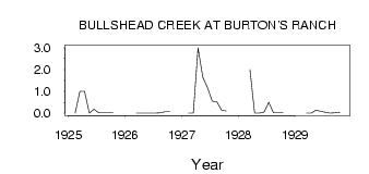
| PointID: | 201 | Code: | 05AH012 | Latitude (decimal degrees): | 49.92 | Longitude (decimal degrees): | -110.65 | Drainage Area (km2): | 411.00 | Source: | Hydat | Hydrological Zone: | Nelson | Name: | BULLSHEAD CREEK AT BURTON'S RANCH |
|---|
| Download | |
|---|---|
| Site Descriptor Information | Site Time Series Data |
| Link to all available data | |
| ID | Year | Jan | Feb | Mar | Apr | May | Jun | Jul | Aug | Sep | Oct | Nov | Dec |
|---|---|---|---|---|---|---|---|---|---|---|---|---|---|
| 201 | 1925 | 0.00 | 1.00 | 1.00 | 1.0e-03 | 0.18 | 0.02 | 0.01 | 0.01 | 0.01 | |||
| 201 | 1926 | 0.00 | 0.00 | 0.00 | 1.0e-03 | 0.00 | 0.01 | 0.06 | 0.06 | ||||
| 201 | 1927 | 0.00 | 0.00 | 3.00 | 1.65 | 1.18 | 0.55 | 0.52 | 0.14 | 0.10 | |||
| 201 | 1928 | 2.00 | 0.00 | 0.00 | 0.05 | 0.50 | 0.01 | 0.01 | 0.01 | ||||
| 201 | 1929 | 0.00 | 0.00 | 0.13 | 0.09 | 0.04 | 4.0e-03 | 0.01 | 0.04 |
 Return to R-Arctic Net Home Page