| PointID: | 197 | Code: | 05AH007 | Latitude (decimal degrees): | 49.85 | Longitude (decimal degrees): | -110.06 | Drainage Area (km2): | 124.00 | Source: | Hydat | Hydrological Zone: | Nelson | Name: | MCALPINE CREEK AT SCHNELL'S RANCH |
|---|
| Download | |
|---|---|
| Site Descriptor Information | Site Time Series Data |
| Link to all available data | |
| ID | Year | Jan | Feb | Mar | Apr | May | Jun | Jul | Aug | Sep | Oct | Nov | Dec |
|---|---|---|---|---|---|---|---|---|---|---|---|---|---|
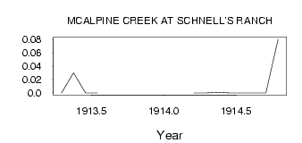
| 197 | 1913 | 0.00 | 0.03 | 0.00 | 0.00 | ||||||||
| 197 | 1914 | 0.00 | 0.00 | 1.0e-03 | 0.00 | 0.00 | 0.00 | 0.00 | 0.08 |
 Return to R-Arctic Net Home Page