| PointID: | 19 | Code: | 05AA024 | Latitude (decimal degrees): | 49.55 | Longitude (decimal degrees): | -113.87 | Drainage Area (km2): | 4400.00 | Source: | Hydat | Hydrological Zone: | Nelson | Name: | OLDMAN RIVER BELOW OLDMAN DAM |
|---|
| Download | |
|---|---|
| Site Descriptor Information | Site Time Series Data |
| Link to all available data | |
| ID | Year | Jan | Feb | Mar | Apr | May | Jun | Jul | Aug | Sep | Oct | Nov | Dec |
|---|---|---|---|---|---|---|---|---|---|---|---|---|---|
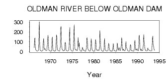
| 19 | 1966 | 41.00 | 129.00 | 141.00 | 52.70 | 22.20 | 14.30 | 11.70 | 8.00 | 6.00 | |||
| 19 | 1967 | 7.00 | 8.00 | 12.00 | 16.00 | 210.00 | 305.00 | 75.00 | 20.70 | 10.90 | 9.74 | 10.00 | 6.00 |
| 19 | 1968 | 5.00 | 9.00 | 11.00 | 15.00 | 102.00 | 133.00 | 50.40 | 22.70 | 26.60 | 31.50 | 19.00 | 12.00 |
| 19 | 1969 | 12.00 | 11.00 | 14.00 | 73.00 | 131.00 | 167.00 | 83.30 | 19.30 | 13.10 | 12.40 | 11.00 | 7.00 |
| 19 | 1970 | 5.00 | 5.00 | 7.00 | 11.00 | 128.00 | 149.00 | 36.80 | 13.70 | 10.90 | 10.10 | 8.00 | 5.00 |
| 19 | 1971 | 5.00 | 11.00 | 9.00 | 31.00 | 171.00 | 156.00 | 51.80 | 19.30 | 13.20 | 13.20 | 9.00 | 8.00 |
| 19 | 1972 | 6.00 | 6.00 | 35.00 | 48.00 | 242.00 | 256.00 | 86.10 | 42.30 | 25.50 | 22.80 | 12.00 | 7.00 |
| 19 | 1973 | 11.00 | 10.00 | 11.00 | 19.00 | 94.40 | 92.50 | 29.80 | 13.60 | 10.50 | 9.18 | 7.00 | 7.00 |
| 19 | 1974 | 9.00 | 9.00 | 14.00 | 48.00 | 167.00 | 245.00 | 71.50 | 30.90 | 17.30 | 11.40 | 10.00 | 7.00 |
| 19 | 1975 | 6.00 | 6.00 | 7.00 | 21.00 | 128.00 | 275.00 | 99.00 | 32.80 | 19.10 | 18.10 | 19.00 | 20.00 |
| 19 | 1976 | 11.00 | 11.00 | 13.00 | 39.00 | 143.00 | 79.60 | 48.50 | 90.80 | 26.10 | 15.00 | 10.00 | 7.00 |
| 19 | 1977 | 5.00 | 7.00 | 6.00 | 21.00 | 44.90 | 34.50 | 12.60 | 13.40 | 15.40 | 11.90 | 7.00 | 7.00 |
| 19 | 1978 | 6.00 | 5.00 | 27.00 | 30.00 | 138.00 | 142.00 | 80.70 | 28.70 | 20.80 | 15.40 | 9.00 | 8.00 |
| 19 | 1979 | 6.00 | 6.00 | 16.00 | 25.00 | 131.00 | 101.00 | 30.30 | 15.30 | 10.30 | 8.07 | 4.00 | 7.00 |
| 19 | 1980 | 4.00 | 5.00 | 6.00 | 47.00 | 124.00 | 103.00 | 26.60 | 15.70 | 17.20 | 14.30 | 12.00 | 19.00 |
| 19 | 1981 | 14.00 | 13.00 | 12.00 | 33.00 | 214.00 | 157.00 | 69.70 | 26.80 | 13.70 | 11.60 | 8.00 | 7.00 |
| 19 | 1982 | 3.00 | 5.00 | 7.00 | 15.00 | 85.30 | 134.00 | 51.20 | 15.40 | 11.90 | 13.10 | 8.00 | 7.00 |
| 19 | 1983 | 6.00 | 9.00 | 9.00 | 23.00 | 84.60 | 76.40 | 40.70 | 14.90 | 8.54 | 7.51 | 9.00 | 5.00 |
| 19 | 1984 | 8.00 | 7.00 | 6.00 | 18.00 | 50.50 | 83.20 | 29.50 | 12.20 | 9.34 | 10.90 | 8.00 | 5.00 |
| 19 | 1985 | 4.00 | 4.00 | 6.00 | 25.00 | 88.30 | 70.30 | 18.20 | 13.30 | 35.10 | 40.30 | 29.00 | 14.00 |
| 19 | 1986 | 9.00 | 29.00 | 38.00 | 56.00 | 143.00 | 113.00 | 27.80 | 13.10 | 15.40 | 27.70 | 15.00 | 11.00 |
| 19 | 1987 | 10.00 | 8.00 | 14.00 | 53.00 | 103.00 | 44.20 | 38.50 | 29.00 | 16.40 | 10.20 | 7.00 | 5.00 |
| 19 | 1988 | 4.00 | 4.00 | 6.00 | 26.00 | 71.90 | 66.80 | 17.90 | 10.70 | 7.80 | 9.86 | 9.00 | 7.00 |
| 19 | 1989 | 4.00 | 4.00 | 6.00 | 31.00 | 101.00 | 116.00 | 37.60 | 17.20 | 21.30 | 16.60 | 31.00 | 18.00 |
| 19 | 1990 | 13.00 | 10.00 | 10.00 | 52.00 | 163.00 | 166.00 | 65.70 | 30.20 | 13.20 | 16.90 | 27.00 | 10.00 |
| 19 | 1991 | 9.00 | 13.00 | 11.00 | 37.00 | 76.80 | 173.00 | 112.00 | 85.70 | 26.80 | 23.10 | 10.00 | 10.00 |
| 19 | 1992 | 8.00 | 8.00 | 8.00 | 12.00 | 38.30 | 23.00 | 20.20 | 15.20 | 15.10 | 13.30 | 9.00 | 8.00 |
| 19 | 1993 | 8.00 | 8.00 | 8.00 | 10.00 | 60.40 | 132.00 | 159.00 | 74.20 | 56.20 | 33.50 | 16.00 | 14.00 |
 Return to R-Arctic Net Home Page