| PointID: | 175 | Code: | 05AG004 | Latitude (decimal degrees): | 49.98 | Longitude (decimal degrees): | -111.72 | Drainage Area (km2): | Source: | Hydat | Hydrological Zone: | Nelson | Name: | BOW RIVER DEVELOPMENT DRAIN A NEAR HAYS |
|---|
| Download | |
|---|---|
| Site Descriptor Information | Site Time Series Data |
| Link to all available data | |
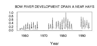
| ID | Year | Jan | Feb | Mar | Apr | May | Jun | Jul | Aug | Sep | Oct | Nov | Dec |
|---|---|---|---|---|---|---|---|---|---|---|---|---|---|
| 175 | 1957 | 7.0e-03 | 0.07 | 0.10 | 0.05 | 0.02 | 0.09 | ||||||
| 175 | 1958 | 0.05 | 0.10 | 0.13 | 0.05 | 0.03 | 0.06 | ||||||
| 175 | 1959 | 7.0e-03 | 0.12 | 0.26 | 0.07 | 0.03 | 0.02 | ||||||
| 175 | 1960 | 8.0e-03 | 0.28 | 0.35 | 0.09 | 0.06 | 0.09 | ||||||
| 175 | 1961 | 0.09 | 0.31 | 0.43 | 0.05 | 0.12 | 0.14 | ||||||
| 175 | 1962 | 0.03 | 0.34 | 0.27 | 0.04 | 0.04 | 0.02 | ||||||
| 175 | 1963 | 0.08 | 0.45 | 0.09 | 0.18 | 0.12 | 0.13 | ||||||
| 175 | 1964 | 0.01 | 0.36 | 0.46 | 0.29 | 0.15 | 0.17 | ||||||
| 175 | 1965 | 0.01 | 0.21 | 0.26 | 0.28 | 0.17 | 0.08 | ||||||
| 175 | 1966 | 0.01 | 0.26 | 0.49 | 0.17 | 0.09 | 0.18 | ||||||
| 175 | 1972 | 0.03 | 0.13 | 0.39 | 0.19 | 0.08 | 0.13 | ||||||
| 175 | 1973 | 0.10 | 0.17 | 0.35 | 0.21 | 0.21 | 0.09 | ||||||
| 175 | 1974 | 0.03 | 0.28 | 0.71 | 0.44 | 0.09 | 0.19 | ||||||
| 175 | 1975 | 0.05 | 0.13 | 0.12 | |||||||||
| 175 | 1976 | 0.06 | 0.41 | 0.49 | 0.26 | 0.14 | 0.14 | ||||||
| 175 | 1977 | 0.22 | 0.32 | 0.53 | 0.31 | 0.11 | 0.09 | ||||||
| 175 | 1978 | 0.05 | 0.11 | 0.47 | 0.26 | 0.04 | 0.07 | ||||||
| 175 | 1979 | 0.04 | 0.33 | 0.61 | 0.38 | 0.03 | 0.12 | ||||||
| 175 | 1980 | 0.40 | 0.40 | 0.72 | 0.26 | 0.08 | 0.12 | ||||||
| 175 | 1981 | 0.06 | 0.27 | 1.00 | 0.26 | 0.26 | 0.15 | ||||||
| 175 | 1982 | 0.02 | 0.35 | 0.64 | 0.34 | 0.09 | 0.14 | ||||||
| 175 | 1983 | 0.04 | 0.50 | 0.39 | 0.18 | 0.11 | 0.07 | ||||||
| 175 | 1984 | 0.10 | 0.35 | 0.35 | 0.19 | 0.06 | 0.03 | ||||||
| 175 | 1989 | 0.19 | 0.33 | 0.76 | 0.38 | 0.25 | 0.07 | ||||||
| 175 | 1990 | 0.06 | 0.27 | 0.72 | 0.18 | 0.25 | 0.23 | ||||||
| 175 | 1991 | 0.06 | 0.57 | 0.34 | 0.27 | 0.17 | 0.15 | ||||||
| 175 | 1992 | 0.33 | 0.28 | 0.57 | 0.28 | 0.17 | 0.12 | ||||||
| 175 | 1993 | 0.06 | 0.25 | 0.43 | 0.13 | 0.17 | 0.11 |
 Return to R-Arctic Net Home Page