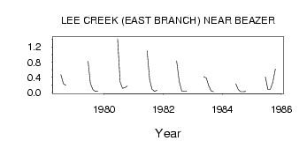
| PointID: | 151 | Code: | 05AE040 | Latitude (decimal degrees): | 49.01 | Longitude (decimal degrees): | -113.53 | Drainage Area (km2): | 37.79 | Source: | Hydat | Hydrological Zone: | Nelson | Name: | LEE CREEK (EAST BRANCH) NEAR BEAZER |
|---|
| Download | |
|---|---|
| Site Descriptor Information | Site Time Series Data |
| Link to all available data | |
| ID | Year | Jan | Feb | Mar | Apr | May | Jun | Jul | Aug | Sep | Oct | Nov | Dec |
|---|---|---|---|---|---|---|---|---|---|---|---|---|---|
| 151 | 1978 | 0.47 | 0.23 | 0.19 | |||||||||
| 151 | 1979 | 0.82 | 0.24 | 0.07 | 0.03 | 0.04 | |||||||
| 151 | 1980 | 1.42 | 0.28 | 0.11 | 0.13 | 0.17 | |||||||
| 151 | 1981 | 1.10 | 0.34 | 0.09 | 0.03 | 0.06 | |||||||
| 151 | 1982 | 0.84 | 0.30 | 0.04 | 0.03 | 0.04 | |||||||
| 151 | 1983 | 0.42 | 0.38 | 0.18 | 0.04 | 0.02 | |||||||
| 151 | 1984 | 0.23 | 0.08 | 0.02 | 0.02 | 0.03 | |||||||
| 151 | 1985 | 0.41 | 0.08 | 0.08 | 0.27 | 0.62 |
 Return to R-Arctic Net Home Page