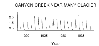
| PointID: | 145 | Code: | 05AE031 | Latitude (decimal degrees): | 48.79 | Longitude (decimal degrees): | -113.62 | Drainage Area (km2): | 19.70 | Source: | Hydat | Hydrological Zone: | Nelson | Name: | CANYON CREEK NEAR MANY GLACIER |
|---|
| Download | |
|---|---|
| Site Descriptor Information | Site Time Series Data |
| Link to all available data | |
| ID | Year | Jan | Feb | Mar | Apr | May | Jun | Jul | Aug | Sep | Oct | Nov | Dec |
|---|---|---|---|---|---|---|---|---|---|---|---|---|---|
| 145 | 1918 | 0.76 | 0.58 | 0.41 | 0.44 | ||||||||
| 145 | 1919 | 1.56 | 0.97 | 0.53 | 0.36 | 0.18 | |||||||
| 145 | 1920 | 1.54 | 0.59 | 0.60 | 0.42 | ||||||||
| 145 | 1921 | 2.76 | 1.27 | 0.49 | 0.48 | 0.60 | |||||||
| 145 | 1922 | 2.35 | 2.73 | 1.11 | 0.54 | 0.33 | 0.19 | ||||||
| 145 | 1923 | 1.61 | 2.64 | 1.22 | 0.70 | 0.32 | 0.42 | ||||||
| 145 | 1924 | 1.42 | 2.24 | 1.13 | 0.61 | 0.29 | |||||||
| 145 | 1925 | 1.92 | 2.54 | 1.40 | 0.66 | 0.52 | 0.33 | ||||||
| 145 | 1926 | 0.82 | 0.97 | 0.64 | 0.40 | 0.77 | |||||||
| 145 | 1927 | 0.97 | 3.37 | 1.69 | 0.99 | 1.45 | 1.05 | ||||||
| 145 | 1928 | 2.10 | 1.91 | 0.64 | 0.43 | 1.12 | |||||||
| 145 | 1929 | 1.88 | 1.90 | 0.92 | 0.40 | 0.20 | 0.25 | ||||||
| 145 | 1930 | 1.59 | 1.99 | 1.08 | 0.43 | 0.53 | 0.27 | ||||||
| 145 | 1931 | 1.70 | 1.16 | 0.68 | 0.55 | 0.64 | 0.26 | ||||||
| 145 | 1932 | 1.56 | 0.80 | 0.47 | 0.24 | 0.31 | |||||||
| 145 | 1933 | 2.49 | 1.29 | 0.59 | 0.42 | 1.05 | |||||||
| 145 | 1934 | 2.83 | 2.81 | 0.92 | 0.44 | 0.20 | 0.24 | ||||||
| 145 | 1935 | 1.68 | 0.96 | 0.45 | 0.40 | 0.23 | |||||||
| 145 | 1936 | 1.91 | 0.73 | 0.37 | 0.21 | 0.18 | |||||||
| 145 | 1937 | 0.88 | 0.46 | 0.17 | 0.40 |
 Return to R-Arctic Net Home Page