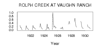
| PointID: | 135 | Code: | 05AE017 | Latitude (decimal degrees): | 49.00 | Longitude (decimal degrees): | -113.15 | Drainage Area (km2): | 86.50 | Source: | Hydat | Hydrological Zone: | Nelson | Name: | ROLPH CREEK AT VAUGHN RANCH |
|---|
| Download | |
|---|---|
| Site Descriptor Information | Site Time Series Data |
| Link to all available data | |
| ID | Year | Jan | Feb | Mar | Apr | May | Jun | Jul | Aug | Sep | Oct | Nov | Dec |
|---|---|---|---|---|---|---|---|---|---|---|---|---|---|
| 135 | 1920 | 0.26 | 0.14 | 0.15 | 0.04 | 0.01 | |||||||
| 135 | 1921 | 0.00 | 0.25 | 0.13 | 0.09 | 0.07 | 0.01 | 0.01 | |||||
| 135 | 1922 | 0.00 | 0.26 | 0.13 | 0.14 | 0.09 | 0.06 | 0.05 | |||||
| 135 | 1923 | 0.15 | 0.37 | 0.18 | 0.13 | 0.06 | 0.04 | ||||||
| 135 | 1924 | 0.00 | 0.00 | 0.10 | 0.34 | 0.08 | 0.16 | 0.07 | 0.02 | ||||
| 135 | 1925 | 0.00 | 1.00 | 0.43 | 0.15 | 0.22 | 0.20 | 0.10 | 0.15 | ||||
| 135 | 1926 | 0.07 | 0.10 | 0.12 | 0.07 | 0.17 | 0.03 | ||||||
| 135 | 1927 | 0.33 | 0.36 | 0.50 | 0.34 | ||||||||
| 135 | 1928 | 0.49 | 0.68 | 0.36 | 0.20 | 0.16 | |||||||
| 135 | 1929 | 0.49 | 0.46 | 0.21 | 0.12 | 0.09 | 0.10 | ||||||
| 135 | 1930 | 0.31 | 0.17 | 0.17 | 0.15 | 0.13 | 0.06 |
 Return to R-Arctic Net Home Page