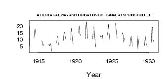
| PointID: | 129 | Code: | 05AE010 | Latitude (decimal degrees): | 49.33 | Longitude (decimal degrees): | -113.04 | Drainage Area (km2): | Source: | Hydat | Hydrological Zone: | Nelson | Name: | ALBERTA RAILWAY AND IRRIGATION CO. CANAL AT SPRING COULEE |
|---|
| Download | |
|---|---|
| Site Descriptor Information | Site Time Series Data |
| Link to all available data | |
| ID | Year | Jan | Feb | Mar | Apr | May | Jun | Jul | Aug | Sep | Oct | Nov | Dec |
|---|---|---|---|---|---|---|---|---|---|---|---|---|---|
| 129 | 1914 | 11.40 | 17.10 | 17.60 | 14.00 | ||||||||
| 129 | 1915 | 8.97 | 8.93 | 6.42 | 5.42 | 6.47 | |||||||
| 129 | 1916 | 6.16 | 5.20 | 6.52 | 6.91 | 4.91 | 1.12 | ||||||
| 129 | 1917 | 7.46 | 12.50 | 11.60 | 5.95 | ||||||||
| 129 | 1918 | 9.21 | 14.30 | 15.40 | 12.40 | 10.20 | |||||||
| 129 | 1919 | 9.59 | 18.70 | 15.00 | 9.16 | 6.77 | |||||||
| 129 | 1920 | 14.90 | 20.20 | 14.40 | 13.60 | 12.80 | |||||||
| 129 | 1921 | 10.50 | 20.90 | 23.40 | 15.90 | 10.70 | |||||||
| 129 | 1922 | 10.50 | 19.50 | 19.50 | 14.60 | 8.49 | 4.54 | ||||||
| 129 | 1923 | 10.70 | 12.80 | 12.60 | 12.40 | 13.40 | 9.14 | ||||||
| 129 | 1924 | 13.40 | 16.00 | 21.40 | 14.00 | 9.94 | |||||||
| 129 | 1925 | 22.10 | 19.80 | 14.70 | 11.20 | ||||||||
| 129 | 1926 | 14.20 | 15.10 | 12.90 | 7.98 | 11.10 | |||||||
| 129 | 1927 | 5.22 | 5.42 | 10.30 | 12.50 | 9.78 | 4.68 | ||||||
| 129 | 1928 | 13.30 | 2.89 | 7.78 | 11.50 | ||||||||
| 129 | 1929 | 5.49 | 12.90 | 9.02 | 5.81 | ||||||||
| 129 | 1930 | 7.90 | 19.40 | 19.20 | 9.81 | 8.33 |
 Return to R-Arctic Net Home Page