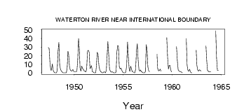
| PointID: | 105 | Code: | 05AD029 | Latitude (decimal degrees): | 48.95 | Longitude (decimal degrees): | -113.90 | Drainage Area (km2): | 160.00 | Source: | Hydat | Hydrological Zone: | Nelson | Name: | WATERTON RIVER NEAR INTERNATIONAL BOUNDARY |
|---|
| Download | |
|---|---|
| Site Descriptor Information | Site Time Series Data |
| Link to all available data | |
| ID | Year | Jan | Feb | Mar | Apr | May | Jun | Jul | Aug | Sep | Oct | Nov | Dec |
|---|---|---|---|---|---|---|---|---|---|---|---|---|---|
| 105 | 1947 | 29.40 | 28.50 | 11.60 | 3.28 | 3.26 | 10.40 | 3.00 | 1.00 | ||||
| 105 | 1948 | 0.00 | 0.00 | 0.00 | 3.00 | 25.60 | 35.50 | 8.39 | 4.01 | 1.73 | 1.09 | 0.00 | 0.00 |
| 105 | 1949 | 0.00 | 0.00 | 0.00 | 5.00 | 25.10 | 21.70 | 7.79 | 2.98 | 2.51 | 2.29 | 4.00 | 2.00 |
| 105 | 1950 | 1.00 | 1.00 | 1.00 | 2.00 | 15.10 | 40.00 | 25.90 | 5.07 | 2.03 | 7.86 | 5.00 | 4.00 |
| 105 | 1951 | 2.00 | 2.00 | 1.00 | 4.00 | 25.40 | 26.40 | 24.00 | 4.98 | 6.51 | 8.49 | 1.00 | 1.00 |
| 105 | 1952 | 0.00 | 0.00 | 0.00 | 8.00 | 24.00 | 21.40 | 8.57 | 3.35 | 1.47 | 0.83 | 0.00 | 0.00 |
| 105 | 1953 | 1.00 | 1.00 | 0.00 | 3.00 | 17.80 | 36.50 | 21.80 | 4.54 | 1.88 | 0.93 | 1.00 | 1.00 |
| 105 | 1954 | 0.00 | 0.00 | 0.00 | 1.00 | 25.20 | 32.00 | 30.60 | 6.91 | 4.50 | 5.64 | 3.00 | 1.00 |
| 105 | 1955 | 0.00 | 0.00 | 0.00 | 1.00 | 9.35 | 35.90 | 18.10 | 3.73 | 1.68 | 7.77 | 4.00 | 1.00 |
| 105 | 1956 | 1.00 | 0.00 | 0.00 | 4.00 | 25.40 | 34.00 | 15.10 | 3.59 | 1.96 | 3.41 | 1.00 | 1.00 |
| 105 | 1957 | 0.00 | 0.00 | 0.00 | 2.00 | 33.00 | 27.30 | 6.92 | 2.19 | 1.32 | |||
| 105 | 1958 | 21.80 | 5.30 | 2.36 | 2.69 | 4.29 | 2.00 | ||||||
| 105 | 1959 | 41.10 | 18.20 | 4.29 | 8.34 | 8.97 | 3.00 | 1.00 | |||||
| 105 | 1960 | 30.60 | 14.10 | 3.39 | 2.11 | 1.74 | 1.00 | 1.00 | |||||
| 105 | 1961 | 0.00 | 40.00 | 8.94 | 2.73 | 1.89 | 4.20 | 1.00 | 0.00 | ||||
| 105 | 1962 | 0.00 | 26.30 | 8.96 | 3.20 | 1.95 | 3.64 | 3.00 | 2.00 | ||||
| 105 | 1963 | 31.50 | 13.10 | 2.91 | 1.85 | 1.28 | 1.00 | 1.00 | |||||
| 105 | 1964 | 49.10 | 17.50 | 2.88 | 2.95 |
 Return to R-Arctic Net Home Page