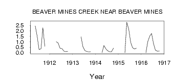
| PointID: | 10 | Code: | 05AA010 | Latitude (decimal degrees): | 49.47 | Longitude (decimal degrees): | -114.15 | Drainage Area (km2): | 62.40 | Source: | Hydat | Hydrological Zone: | Nelson | Name: | BEAVER MINES CREEK NEAR BEAVER MINES |
|---|
| Download | |
|---|---|
| Site Descriptor Information | Site Time Series Data |
| Link to all available data | |
| ID | Year | Jan | Feb | Mar | Apr | May | Jun | Jul | Aug | Sep | Oct | Nov | Dec |
|---|---|---|---|---|---|---|---|---|---|---|---|---|---|
| 10 | 1911 | 2.45 | 1.48 | 0.28 | 0.36 | 2.28 | 0.57 | ||||||
| 10 | 1912 | 1.00 | 0.89 | 0.40 | 0.37 | 0.15 | 0.09 | 0.13 | |||||
| 10 | 1913 | 1.45 | 0.55 | 0.19 | 0.11 | 0.07 | 0.09 | ||||||
| 10 | 1914 | 0.00 | 0.66 | 0.35 | 0.17 | 0.08 | 0.09 | 0.42 | |||||
| 10 | 1915 | 0.00 | 2.79 | 2.16 | 0.95 | 0.46 | 0.34 | 0.42 | |||||
| 10 | 1916 | 0.00 | 1.00 | 1.52 | 1.76 | 0.83 | 0.24 | 0.14 | 0.15 |
 Return to R-Arctic Net Home Page